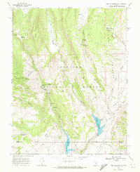
1968 Map of Forsyth Reservoir
USGS Topo · Published 1972About this map
Fish Lake National Forest dominates this high-elevation landscape, where drainage from Zedds Mountain and Tidwell Canyon feeds into a network of reservoirs. The 1968 field-check reveals a recreational and resource-managed environment defined by water management, notably at Forsyth Reservoir and Mill Meadow Reservoir, both noted with their respective spillway elevations. The presence of numerous designated sites like Pah Ga Ne A Campground and Toats Campground suggests a period of established forest service infrastructure. This area, straddling the Sevier and Wayne County line, is marked by family-named landmarks such as Zedds Meadows and Danish Meadows, indicating earlier grazing or settlement ties. Remote access is characterized by a series of labels for Jeep Trails and Pack Trails that navigate the steep terrain of Ivie Canyon and Splatter Canyon.
Find a feature on this map
36 named features on this map. Tap any name to fly to it.
Don’t see what you’re looking for? This feature index may not catch every label — zoom into the map to look around manually.
Map Details
Editions of this 1968 Forsyth Reservoir Map
This is the sole edition of this map. No revisions or reprints were ever made.
Other maps of this area

1885 · Fish Lake
USGS Topo · 1:250,000

1896 · Fish Lake
USGS Topo · 1:250,000

1922 · Emery No.3
USGS Topo · 1:31,680

1952 · Notom 2 NW
USGS Topo · 1:24,000

1952 · Torrey
USGS Topo · 1:62,500

1952 · Loa 1 NE
USGS Topo · 1:24,000

1956 · Salina
USGS Topo · 1:250,000

1960 · Salina
USGS Topo · 1:250,000

1962 · Salina
USGS Topo · 1:250,000

1967 · Lyman
USGS Topo · 1:24,000