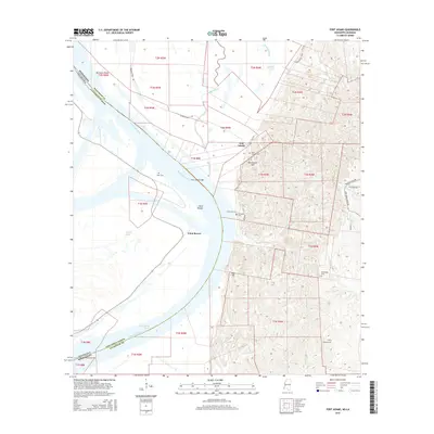
2015 Map of Fort Adams
USGS Topo · Published 2015About this map
Fort Adams and the surrounding river bluffs in Wilkinson County dominate this 2015 survey, revealing a landscape defined by the shifting course of the Mississippi River. The rugged topography east of the river is punctuated by family and community landmarks like Blockhouse Hill and several burial grounds, including Saint Joseph Cem and the Clarksville Cem. The river's influence is evident in the broad, low-lying reaches of Point Breeze and the expansive Fort Adams Bar, while the upland interior is drained by a network of waterways such as the Buffalo River and Clark Cr. This modern map preserves the historical settlement patterns of southwestern Mississippi, where the steep terrain met the vital transport corridor of the Fort Adams Reach. Genealogists will find particular value in the scattered cemeteries like Linwood Cem and Mess Ridge Cem, which anchor the lineage of this riverfront region across generations.
Find a feature on this map
42 named features on this map. Tap any name to fly to it.
Don’t see what you’re looking for? This feature index may not catch every label — zoom into the map to look around manually.
Map Details
Editions of this 2015 Fort Adams Map
This is the sole edition of this map. No revisions or reprints were ever made.
Other maps of this area

1906 · Bayou Sara
USGS Topo · 1:125,000

1936 · Woodville
USGS Topo · 1:62,500

1939 · St. Francisville
USGS Topo · 1:62,500

1939 · Artonish
USGS Topo · 1:62,500

1941 · Batchelor
USGS Topo · 1:62,500

1953 · Natchez
USGS Topo · 1:250,000

1954 · Artonish
USGS Topo · 1:62,500

1954 · Baton Rouge
USGS Topo · 1:250,000

1955 · Artonish
USGS Topo · 1:62,500

1955 · Batchelor
USGS Topo · 1:62,500