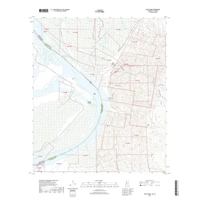
2018 Map of Fort Adams
USGS Topo · Published 2018About this map
The Mississippi River forms a jagged border between Mississippi and Louisiana in this corner of Wilkinson County, dominated by the settlement of Fort Adams. This strategic high ground is marked by Blockhouse Hill and Saint Joseph Cem, overlooking the intricate network of the Fort Adams Reach and the Fort Adams Bar. The landscape is a complex hybrid of river-bottom wetlands and upland ridges, where the Buffalo River and Old Homochitto River meander through dense sloughs like Belmont Slough. To the east, the terrain rises sharply into the loess bluffs, home to Rock Hill and several smaller family-named burial grounds including Clarksville Cem, Riverside Cem, and Mess Ridge Cem. This geography reveals a long history of river navigation and early settlement, with many roads like Jackson Point Rd and Ft Adams Pond Rd following the natural contours of the bluffs and riverbanks.
Find a feature on this map
50 named features on this map. Tap any name to fly to it.
Don’t see what you’re looking for? This feature index may not catch every label — zoom into the map to look around manually.
Map Details
Editions of this 2018 Fort Adams Map
This is the sole edition of this map. No revisions or reprints were ever made.
Other maps of this area

1906 · Bayou Sara
USGS Topo · 1:125,000

1936 · Woodville
USGS Topo · 1:62,500

1939 · St. Francisville
USGS Topo · 1:62,500

1939 · Artonish
USGS Topo · 1:62,500

1941 · Batchelor
USGS Topo · 1:62,500

1953 · Natchez
USGS Topo · 1:250,000

1954 · Artonish
USGS Topo · 1:62,500

1954 · Baton Rouge
USGS Topo · 1:250,000

1955 · Artonish
USGS Topo · 1:62,500

1955 · Batchelor
USGS Topo · 1:62,500