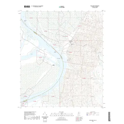
2020 Map of Fort Adams
USGS Topo · Published 2020About this map
The Mississippi River carves a massive bend through this landscape, marking the historic boundary between Mississippi and Louisiana at Point Breeze. The settlement of Fort Adams sits atop the high ground overlooking the river, characterized by its elevation at Blockhouse Hill and its concentration of local history sites like Saint Joseph Cem. The area’s river-dependent geography is evident in the Fort Adams Reach and the expansive Fort Adams Bar, while the interior is defined by a dense network of drainage including Clark Cr and Buffalo River. For those tracing family history, the map preserves the locations of several burial grounds scattered across the hills and bottoms, including Knox Cem, Riverside Cem, and the remote Mess Ridge Cem. The transition from the alluvial plain at Palmetto Point to the uplands of Rock Hill illustrates the varied terrain of the lower Mississippi valley.
Find a feature on this map
47 named features on this map. Tap any name to fly to it.
Don’t see what you’re looking for? This feature index may not catch every label — zoom into the map to look around manually.
Map Details
Editions of this 2020 Fort Adams Map
This is the sole edition of this map. No revisions or reprints were ever made.
Other maps of this area

1906 · Bayou Sara
USGS Topo · 1:125,000

1936 · Woodville
USGS Topo · 1:62,500

1939 · St. Francisville
USGS Topo · 1:62,500

1939 · Artonish
USGS Topo · 1:62,500

1941 · Batchelor
USGS Topo · 1:62,500

1953 · Natchez
USGS Topo · 1:250,000

1954 · Artonish
USGS Topo · 1:62,500

1954 · Baton Rouge
USGS Topo · 1:250,000

1955 · Artonish
USGS Topo · 1:62,500

1955 · Batchelor
USGS Topo · 1:62,500