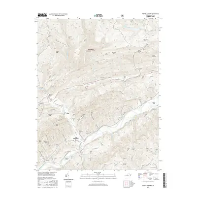
2016 Map of Fort Blackmore
USGS Topo · Published 2016About this map
Fort Blackmore and the surrounding Scott County landscape are defined by the winding course of the Clinch River as it cuts through the Appalachian ridges. This area of Southwest Virginia is a patchwork of family lineage, evidenced by the dense distribution of burial grounds such as the John Wesley Cem, Gillenwater Family Cem, and Quillen Cox Cem. The terrain is characterized by steep, parallel ridges including Stone Mountain and Copper Ridge, which confine human settlement to narrow valleys like Back Valley and Hunter Valley. To the north, the Jefferson National Forest covers high ground where Bark Camp Lake and Chimney Rock serve as landmarks. The map also captures local transport nodes like the Glenn Carter Memorial Bridge and the cluster of small communities at Wood, Lano, and Kerns that follow the river and mountain gaps.
Find a feature on this map
139 named features on this map. Tap any name to fly to it.
Don’t see what you’re looking for? This feature index may not catch every label — zoom into the map to look around manually.
Map Details
Editions of this 2016 Fort Blackmore Map
This is the sole edition of this map. No revisions or reprints were ever made.
Other maps of this area

1894 · Estillville
USGS Topo · 1:125,000

1897 · Bristol
USGS Topo · 1:125,000

1902 · Bristol
USGS Topo · 1:125,000

1920 · Wise
USGS Topo · 1:48,000

1920 · Coeburn
USGS Topo · 1:48,000

1921 · Wise
USGS Topo · 1:62,500

1935 · Hilton
USGS Topo · 1:24,000
1935 · Wise
USGS Topo · 1:24,000

1935 · Moggasin
USGS Topo · 1:48,000
1935 · Norton
USGS Topo · 1:24,000