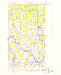
1951 Map of Fort Fairfield
USGS Topo · Published 1952About this map
The Aroostook River valley defines this borderlands landscape, where the agricultural and transit networks of northern Maine meet New Brunswick. In the early 1950s, the region was heavily served by the Bangor and Aroostook and Canadian Pacific railroads, which facilitated the movement of goods through hubs like Fort Fairfield and Limestone. The map reveals a dense pattern of rural schoolhouses and corners, such as Kelly Sch, Palmer Sch, Cote Corner, and Somers Corner, reflecting the established community structure of the time. Along the Little Madawaska River, the presence of the State Fish Hatchery and Grimes Mill highlights the local reliance on the area's complex water systems, which include Sawyer Bog and numerous brooks like Brandy Brook and Nichols Brook. The international boundary is clearly marked, showing the proximity of settlements like Brissettes to the Canadian line.
Find a feature on this map
81 named features on this map. Tap any name to fly to it.
Don’t see what you’re looking for? This feature index may not catch every label — zoom into the map to look around manually.
Map Details
Editions of this 1951 Fort Fairfield Map
5 editions found

Other maps of this area

1921 · Van Buren
USGS Topo · 1:250,000

1927 · Stockholm
USGS Topo · 1:48,000

1929 · Caribou
USGS Topo · 1:48,000

1930 · Fort Fairfield
USGS Topo · 1:48,000

1931 · Van Buren
USGS Topo · 1:48,000

1931 · Stockholm
USGS Topo · 1:62,500

1932 · Caribou
USGS Topo · 1:62,500

1933 · Fort Fairfield
USGS Topo · 1:62,500

1934 · Van Buren
USGS Topo · 1:62,500

1935 · Presque Isle
USGS Topo · 1:62,500