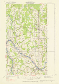
1951 Map of Fort Fairfield
USGS Topo · Published 1958About this map
The Aroostook River winds through the heart of this Maine landscape, serving as a corridor for both the Canadian Pacific and Bangor and Aroostook railroads during the mid-century. This survey, revised in 1951 from earlier aerial photography, documents the agricultural and civic density of the border region where Limestone and Fort Fairfield meet the Canadian frontier. Local commerce and transit are centered around points like Grimes Mill and the village of Caribou, while the rural uplands are dotted with family-named junctions such as Brown Corner, Cote Corner, and Somers Corner. The map reveals a highly developed network of rural education and social infrastructure, evidenced by numerous named schools including the Willard School and Wright Sch. Notable land use features include the State Fish Hatchery and the vast Sawyer Bog, illustrating the mix of managed resources and natural wetlands characteristic of the county.
Find a feature on this map
77 named features on this map. Tap any name to fly to it.
Don’t see what you’re looking for? This feature index may not catch every label — zoom into the map to look around manually.
Map Details
Editions of this 1951 Fort Fairfield Map
5 editions found

Other maps of this area

1921 · Van Buren
USGS Topo · 1:250,000

1927 · Stockholm
USGS Topo · 1:48,000

1929 · Caribou
USGS Topo · 1:48,000

1930 · Fort Fairfield
USGS Topo · 1:48,000

1931 · Van Buren
USGS Topo · 1:48,000

1931 · Stockholm
USGS Topo · 1:62,500

1932 · Caribou
USGS Topo · 1:62,500

1933 · Fort Fairfield
USGS Topo · 1:62,500

1934 · Van Buren
USGS Topo · 1:62,500

1935 · Presque Isle
USGS Topo · 1:62,500