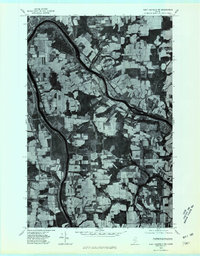
1975 Map of Fort Fairfield SW
USGS Topo · Published 1981About this map
The agricultural geometry of Aroostook County is etched into this orthophotoquad, where the Little Madawaska River winds through a dense mosaic of potato fields and woodland. The image shows the landscape as it appeared in the mid-1970s, highlighting the proximity of rural settlements like Grimes Mill and East Lyndon to the eastern edge of Caribou. This aerial perspective reveals the persistence of family-named localities such as Hurd and Goodwin, providing a clear view of the road networks and land divisions that shaped local life during this era of Maine's farming history. The stark contrast between the cultivated rectangles and the winding river corridor captures the region's historical reliance on both its fertile soil and its water resources.
Find a feature on this map
6 named features on this map. Tap any name to fly to it.
Don’t see what you’re looking for? This feature index may not catch every label — zoom into the map to look around manually.
Map Details
Editions of this 1975 Fort Fairfield SW Map
This is the sole edition of this map. No revisions or reprints were ever made.
Other maps of this area

1929 · Caribou
USGS Topo · 1:48,000

1930 · Fort Fairfield
USGS Topo · 1:48,000

1932 · Caribou
USGS Topo · 1:62,500

1933 · Fort Fairfield
USGS Topo · 1:62,500

1935 · Presque Isle
USGS Topo · 1:62,500

1936 · Mars Hill
USGS Topo · 1:48,000

1940 · Mars Hill
USGS Topo · 1:62,500

1951 · Mars Hill
USGS Topo · 1:62,500

1951 · Fort Fairfield
USGS Topo · 1:62,500

1953 · Fort Fairfield NW
USGS Topo · 1:24,000