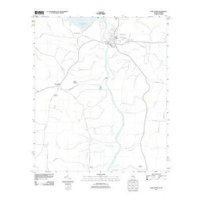
2011 Map of Fort Gaines
USGS Topo · Published 2011About this map
Fort Gaines, Georgia, sits at the center of this 2011 survey, overlooking the Chattahoochee River as it forms the state line with Alabama. The landscape is dominated by the massive Walter F George Lock and Dam and the southern reach of the Walter F George Reservoir. Local history is preserved in several burial grounds including Rose Hill Cemetery and New Park Cemetery, while the Henry G McKemie Bridge provides a vital interstate link. On the Alabama side, the settlement of Shorterville connects via a network of rural roads such as County Hwy-97. The map detail shows the transition from the river's industrial management at the W C Wills Dam to the agricultural reaches of Farmers Landing, with numerous tributaries like McRae Mill Creek and Roaring Branch feeding the primary waterway.
Find a feature on this map
48 named features on this map. Tap any name to fly to it.
Don’t see what you’re looking for? This feature index may not catch every label — zoom into the map to look around manually.
Map Details
Editions of this 2011 Fort Gaines Map
This is the sole edition of this map. No revisions or reprints were ever made.
Other maps of this area

1953 · Dothan
USGS Topo · 1:250,000

1954 · Dothan
USGS Topo · 1:250,000

1955 · Dothan
USGS Topo · 1:250,000

1969 · Fort Gaines
USGS Topo · 1:24,000

1969 · Fort Gaines NW
USGS Topo · 1:24,000

1969 · Fort Gaines NE
USGS Topo · 1:24,000

1969 · Abbeville East
USGS Topo · 1:24,000

1970 · Columbia NE
USGS Topo · 1:24,000

1970 · Haleburg
USGS Topo · 1:24,000
1973 · Coleman
USGS Topo · 1:24,000