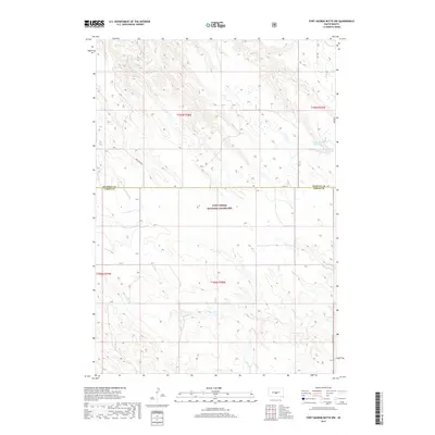
2017 Map of Fort George Butte NW
USGS Topo · Published 2017About this map
Fort Pierre National Grassland dominates the southern portion of this landscape where the Lyman and Stanley county lines meet. The terrain is defined by a dendritic network of drainages, including Antelope Cr in the northwest and Timber Cr in the northeast, which carve through the high plains. A small body of water, Williams Reservoir, provides a rare permanent catchment in an area otherwise characterized by ephemeral runs like Cedar Cr and S Br Cedar Cr. The road network is sparse, consisting of section-line routes such as 302nd Ave and local thoroughfares like Warcreek Rd, reflecting the large-scale ranching and conservation efforts common to this part of South Dakota.
Find a feature on this map
15 named features on this map. Tap any name to fly to it.
Don’t see what you’re looking for? This feature index may not catch every label — zoom into the map to look around manually.
Map Details
Editions of this 2017 Fort George Butte NW Map
This is the sole edition of this map. No revisions or reprints were ever made.
Other maps of this area

1924 · Pierre
USGS Topo · 1:62,500

1934 · Canning
USGS Topo · 1:48,000

1937 · Canning
USGS Topo · 1:62,500

1954 · Pierre
USGS Topo · 1:250,000

1958 · Pierre
USGS Topo · 1:250,000

1966 · Ft. George Butte SE
USGS Topo · 1:24,000

1967 · Ft. George Butte NW
USGS Topo · 1:24,000

1967 · Ft. George Butte SW
USGS Topo · 1:24,000
1967 · Ft. George Butte
USGS Topo · 1:24,000

1972 · Pierre 3 SE
USGS Topo · 1:24,000