
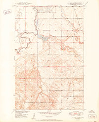
1948 Map of Fort Kipp
USGS Topo · Published 1989About this map
Big Muddy Creek meanders deeply across the northeastern corner of the Fort Peck Indian Reservation, defining a landscape where the river plain meets the rising upland coulees of Roosevelt County. This 1948 survey, updated with later revisions, shows the rural community life centered around Fort Kipp and the neighboring settlement of Blair. The cultural footprint of the era is evident in the cluster of the Freidens Ch and Freidens Cem near the northern boundary, alongside infrastructure such as a Windmill and several Gravel Pits that supported local ranching and road maintenance. The map captures the transitional terrain between the Roosevelt and Richland County line, documenting the early post-war development of the Missouri River Basin project while maintaining its character as a remote pocket of the High Plains.
Find a feature on this map
12 named features on this map. Tap any name to fly to it.
Don’t see what you’re looking for? This feature index may not catch every label — zoom into the map to look around manually.
Map Details
Editions of this 1948 Fort Kipp Map
This is the sole edition of this map. No revisions or reprints were ever made.
Other maps of this area

1909 · Smoke Creek
USGS Topo · 1:62,500

1912 · Smoke Creek
USGS Topo · 1:62,500

1914 · Brockton
USGS Topo · 1:62,500

1914 · Homestead
USGS Topo · 1:62,500

1947 · Rocky Point
USGS Topo · 1:24,000

1948 · Rocky Point
USGS Topo · 1:24,000

1949 · Fort Kipp
USGS Topo · 1:24,000

1949 · Johnson Lake
USGS Topo · 1:24,000
1950 · Johnson Lake
USGS Topo · 1:24,000

1950 · Coyote Coulee
USGS Topo · 1:24,000
Featured Places
- Fort Kipp District, MT
- Fort Kipp, Fort Kipp District
- Richland County, MT
- Roosevelt County, MT
- United States