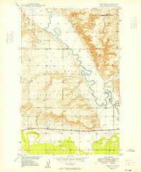
1949 Map of Fort Kipp
USGS Topo · Published 1949About this map
Fort Peck Indian Reservation lands dominate this late-1940s landscape, where the meandering course of Big Muddy Creek carves through the Missouri River Basin. The settlement of Fort Kipp and the nearby community of Blair serve as focal points along the southern edge, situated just north of the Great Northern railroad line. This period of development shows a mix of spiritual and physical infrastructure, from the Freidens Ch and its accompanying Freidens Cem in the north to active industrial sites like a Gravel Pit near the river valley.
Find a feature on this map
14 named features on this map. Tap any name to fly to it.
Don’t see what you’re looking for? This feature index may not catch every label — zoom into the map to look around manually.
Map Details
Editions of this 1949 Fort Kipp Map
2 editions found
Other maps of this area

1909 · Smoke Creek
USGS Topo · 1:62,500

1912 · Smoke Creek
USGS Topo · 1:62,500

1914 · Brockton
USGS Topo · 1:62,500

1914 · Homestead
USGS Topo · 1:62,500

1947 · Rocky Point
USGS Topo · 1:24,000

1948 · Rocky Point
USGS Topo · 1:24,000

1948 · Fort Kipp
USGS Topo · 1:24,000

1949 · Fort Kipp
USGS Topo · 1:24,000

1949 · Johnson Lake
USGS Topo · 1:24,000
1950 · Johnson Lake
USGS Topo · 1:24,000
Featured Places
- Fort Kipp District, MT
- Fort Kipp, Fort Kipp District
- Richland County, MT
- Roosevelt County, MT
- United States