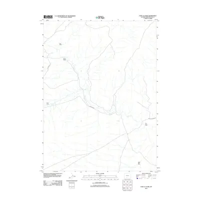
2012 Map of Fort La Clede
USGS Topo · Published 2012About this map
The Overland Emigrant Rd traces a historical path across the high desert of Sweetwater County, marking a corridor once vital to westward expansion. This landscape is defined by its drainage network, where Bitter Cr and Antelope Cr carve through the arid terrain. The presence of these intermittent water sources influenced the placement of early travel routes and modern access points like Bitter Creek Rd. Named topographic depressions such as Hungry Hollow, Long Draw, and Red Wash suggest a difficult environment for early travelers and homesteaders alike. From the eastern edge at Iron Pipe Draw to the southern reach of Eagle Nest Draw, the map provides a clear picture of the land's hydrology and the infrastructure, such as Blm Road 4409, used to navigate this remote portion of Wyoming in the early 21st century.
Find a feature on this map
10 named features on this map. Tap any name to fly to it.
Don’t see what you’re looking for? This feature index may not catch every label — zoom into the map to look around manually.
Map Details
Editions of this 2012 Fort La Clede Map
This is the sole edition of this map. No revisions or reprints were ever made.
Other maps of this area

1954 · Rock Springs
USGS Topo · 1:250,000

1958 · Rock Springs
USGS Topo · 1:250,000

1962 · Rock Springs
USGS Topo · 1:250,000

1968 · Bitter Creek
USGS Topo · 1:24,000

1968 · Sand Butte Rim SE
USGS Topo · 1:24,000
1968 · Antelope Flats
USGS Topo · 1:24,000
1970 · Kinney Spring
USGS Topo · 1:24,000

1970 · Table Rock
USGS Topo · 1:24,000

1970 · Manuel Gap
USGS Topo · 1:24,000

1970 · J O Dugway
USGS Topo · 1:24,000