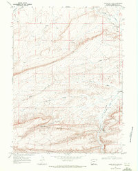
1968 Map of Antelope Flats
USGS Topo · Published 1972About this map
Overland Trail history is etched into this high-desert landscape, where the historic stage and wagon route crosses the northeast corner near Bitter Creek. The 1968 survey reveals a terrain defined by massive escarpments, including the prominent Sixmile Rim and the Sand Butte Rim to the south. Water is the primary driver of names and activity in this arid region, from the crucial Antelope Springs and Barney Meadows Spring to the seasonal drainage of Patrick Draw.
Find a feature on this map
22 named features on this map. Tap any name to fly to it.
Don’t see what you’re looking for? This feature index may not catch every label — zoom into the map to look around manually.
Map Details
Editions of this 1968 Antelope Flats Map
2 editions found
Other maps of this area

1954 · Rock Springs
USGS Topo · 1:250,000

1958 · Rock Springs
USGS Topo · 1:250,000

1962 · Rock Springs
USGS Topo · 1:250,000

1968 · Sand Butte Rim NW
USGS Topo · 1:24,000

1968 · Bitter Creek
USGS Topo · 1:24,000

1968 · Black Buttes
USGS Topo · 1:24,000

1968 · Pine Butte
USGS Topo · 1:24,000

1968 · Sand Butte Rim SE
USGS Topo · 1:24,000
1970 · Kinney Spring
USGS Topo · 1:24,000

1970 · Table Rock
USGS Topo · 1:24,000