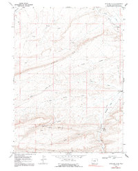
1968 Map of Antelope Flats
USGS Topo · Published 1992About this map
Overland Trail traces a path through the northeastern corner of this high-desert landscape, passing the Big Pond Station (Ruins) near the banks of Bitter Creek. This area of Sweetwater County is defined by prominent topographical escarpments, most notably the Sixmile Rim and Sand Butte Rim, which create a complex system of plateaus and dry washes. The map documents a sparsely populated but active resource landscape, indicated by numerous scattered Drill Holes and a Gas Well across the flats. Seasonal water sources and localized meadows like Barney Meadows and Antelope Springs provide the only breaks in the arid terrain. The presence of Antelope Bridge and various unimproved roads suggests a network of access points used for livestock grazing and energy exploration during the late 1960s.
Find a feature on this map
20 named features on this map. Tap any name to fly to it.
Don’t see what you’re looking for? This feature index may not catch every label — zoom into the map to look around manually.
Map Details
Editions of this 1968 Antelope Flats Map
2 editions found
Other maps of this area

1954 · Rock Springs
USGS Topo · 1:250,000

1958 · Rock Springs
USGS Topo · 1:250,000

1962 · Rock Springs
USGS Topo · 1:250,000

1968 · Sand Butte Rim NW
USGS Topo · 1:24,000

1968 · Bitter Creek
USGS Topo · 1:24,000

1968 · Black Buttes
USGS Topo · 1:24,000

1968 · Pine Butte
USGS Topo · 1:24,000

1968 · Sand Butte Rim SE
USGS Topo · 1:24,000
1968 · Antelope Flats
USGS Topo · 1:24,000
1970 · Kinney Spring
USGS Topo · 1:24,000