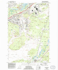
1959 Map of Fort Lewis
USGS Topo · Published 1994About this map
The Fort Lewis Military Reservation dominates this 1990s revision, showcasing the extensive infrastructure of one of the Pacific Northwest's primary military installations. The landscape is a complex mix of tactical training areas and permanent facility hubs, anchored by the Madigan Army Medical Center and the Gray Army Air Field. To the north, the Mount Rainier Ordnance Depot and Camp Murray National Guard sit near the shores of American Lake, which features several named islands like Barlow Island and Cors Island. The map records a dense network of firing ranges, lookouts, and training bluffs such as 6th Engineer Bluff. Beyond the cantonment areas, the southern reaches transition into the Ninety-first Division prairie and the wetlands of Brandenburg Marsh, eventually meeting the civilian settlement of Roy along Muck Creek. Genealogists will find value in the clearly marked Fort Lewis Cem and Ross Cem, alongside several local schools including Hillside Sch and Evergreen Sch.
Find a feature on this map
144 named features on this map. Tap any name to fly to it.
Don’t see what you’re looking for? This feature index may not catch every label — zoom into the map to look around manually.
Map Details
Editions of this 1959 Fort Lewis Map
4 editions found
Other maps of this area

1897 · Tacoma
USGS Topo · 1:125,000

1900 · Tacoma
USGS Topo · 1:125,000

1916 · Chehalis
USGS Topo · 1:125,000

1937 · Eatonville
USGS Topo · 1:125,000

1940 · Anderson Island
USGS Topo · 1:62,500

1941 · Tanwax Lake
USGS Topo · 1:62,500

1941 · Tacoma South
USGS Topo · 1:62,500

1944 · Tacoma South
USGS Topo · 1:62,500

1944 · Yelm
USGS Topo · 1:62,500

1944 · Ohop Valley
USGS Topo · 1:62,500