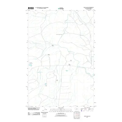
2011 Map of Fort Logan
USGS Topo · Published 2011About this map
Fort Logan serves as the focal point of this Meagher County landscape, situated near the winding course of the Smith River. The area is defined by a sophisticated network of water management and irrigation, including Ayers Reservoir, Keep Cool Reservoir, and Doggett Reservoir, each supported by their respective dams. The map documents the local geography where drainages like Camas Creek, Elk Creek, and Beaver Creek converge, reflecting the importance of water rights in this cattle-ranching region. Evidence of early settlement and genealogy is preserved at the Kinyon Cemetery, while the recreational value of the river is noted at the Smith River Sportmans Access. The terrain is further detailed through named features such as Benton Gulch and Ayers Gulch, connected by a network of rural routes including HWY 360 and Camas Creek Rd.
Find a feature on this map
27 named features on this map. Tap any name to fly to it.
Don’t see what you’re looking for? This feature index may not catch every label — zoom into the map to look around manually.
Map Details
Editions of this 2011 Fort Logan Map
This is the sole edition of this map. No revisions or reprints were ever made.
Other maps of this area

1886 · Fort Logan
USGS Topo · 1:250,000

1948 · White Sulphur Springs
USGS Topo · 1:250,000

1958 · White Sulphur Springs
USGS Topo · 1:250,000

1961 · White Sulphur Springs
USGS Topo · 1:250,000

1965 · White Sulphur Springs
USGS Topo · 1:250,000

1966 · Boulder Baldy
USGS Topo · 1:24,000

1966 · Watson
USGS Topo · 1:24,000
1966 · Ellis Canyon
USGS Topo · 1:24,000
1971 · Whitetail Reservoir
USGS Topo · 1:24,000
1971 · Sheep Mountain
USGS Topo · 1:24,000