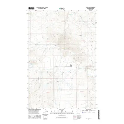
2017 Map of Fort Logan
USGS Topo · Published 2017About this map
Fort Logan and the winding Smith River define this Montana landscape, where agricultural water management and high-plains topography converge. The presence of Soldiers Lake and multiple irrigation points like Doggett Reservoir, Keep Cool Reservoir, and Ayers Reservoir illustrates a sophisticated network of water control designed to support the local ranching economy. This 2017 survey details a terrain marked by significant drainage systems including Camas Cr, Cottonwood Cr, and Beaver Cr, which carve through the land alongside landmarks such as Benton Gulch. For local historians and genealogists, the Kinyon Cem remains a notable point of interest, situated near the intersection of the river and Fort Logan Rd. The area is accessible via a network of rural routes such as Smith River Rd and Lingshire Rd, reflecting the enduring settlement patterns of Meagher County.
Find a feature on this map
30 named features on this map. Tap any name to fly to it.
Don’t see what you’re looking for? This feature index may not catch every label — zoom into the map to look around manually.
Map Details
Editions of this 2017 Fort Logan Map
This is the sole edition of this map. No revisions or reprints were ever made.
Other maps of this area

1886 · Fort Logan
USGS Topo · 1:250,000

1948 · White Sulphur Springs
USGS Topo · 1:250,000

1958 · White Sulphur Springs
USGS Topo · 1:250,000

1961 · White Sulphur Springs
USGS Topo · 1:250,000

1965 · White Sulphur Springs
USGS Topo · 1:250,000

1966 · Boulder Baldy
USGS Topo · 1:24,000

1966 · Watson
USGS Topo · 1:24,000
1966 · Ellis Canyon
USGS Topo · 1:24,000
1971 · Whitetail Reservoir
USGS Topo · 1:24,000
1971 · Sheep Mountain
USGS Topo · 1:24,000