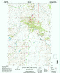
1995 Map of Fort Logan
USGS Topo · Published 1997About this map
Fort Logan and the legacy of the western frontier define this landscape in Meagher County. The presence of the Old Military Reservation Boundary provides a clear spatial link to the region's 19th-century history, while the Kinyon Cem offers a specific point of interest for genealogists and local historians. The Smith River snakes through the center of the sheet, joined by numerous tributaries including Cottonwood Creek and Whitetail Deer Creek.
Find a feature on this map
22 named features on this map. Tap any name to fly to it.
Don’t see what you’re looking for? This feature index may not catch every label — zoom into the map to look around manually.
Map Details
Editions of this 1995 Fort Logan Map
This is the sole edition of this map. No revisions or reprints were ever made.
Other maps of this area

1886 · Fort Logan
USGS Topo · 1:250,000

1948 · White Sulphur Springs
USGS Topo · 1:250,000

1958 · White Sulphur Springs
USGS Topo · 1:250,000

1961 · White Sulphur Springs
USGS Topo · 1:250,000

1965 · White Sulphur Springs
USGS Topo · 1:250,000

1966 · Boulder Baldy
USGS Topo · 1:24,000

1966 · Watson
USGS Topo · 1:24,000
1966 · Ellis Canyon
USGS Topo · 1:24,000
1971 · Whitetail Reservoir
USGS Topo · 1:24,000
1971 · Sheep Mountain
USGS Topo · 1:24,000