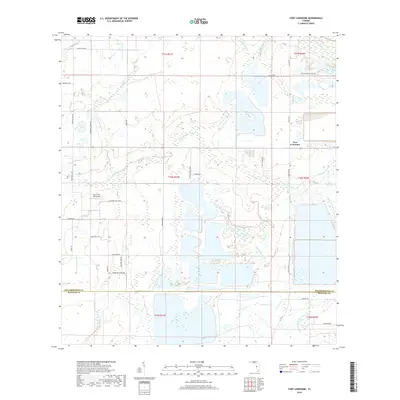
2018 Map of Fort Lonesome
USGS Topo · Published 2018About this map
Fort Lonesome serves as a central reference point in this landscape where Hillsborough and Manatee counties meet. The area is defined by a dense network of hydrologic features, most notably the winding course of the Little Manatee River and its S Fork Little Manatee River, which dictate the drainage patterns for numerous local tributaries like Howard Prairie Br and Pierce Branch. Large-scale land alterations are evident through the geometric basins and reservoirs that dominate the eastern and southern sections of the map, contrasting with the more natural, riparian wetlands of Hurrah Bay and Carlton Lake. Transportation in this rural corridor relies on a grid of local roads named for prominent residents, such as Alderman Turner Rd and Keene Rd. The presence of the Gyro Town USA Airport highlights the specialized aviation activity found in this part of Florida, while the surrounding terrain remains primarily dedicated to water management and agricultural ranchettes.
Find a feature on this map
47 named features on this map. Tap any name to fly to it.
Don’t see what you’re looking for? This feature index may not catch every label — zoom into the map to look around manually.
Map Details
Editions of this 2018 Fort Lonesome Map
This is the sole edition of this map. No revisions or reprints were ever made.
Other maps of this area

1921 · Tampa
USGS Topo · 1:62,500

1944 · Rye
USGS Topo · 1:31,680

1944 · Wimauma
USGS Topo · 1:31,680

1944 · Balm
USGS Topo · 1:31,680

1947 · Wimauma
USGS Topo · 1:25,000

1955 · Lithia
USGS Topo · 1:24,000

1955 · Keysville
USGS Topo · 1:24,000
1956 · Riverview
USGS Topo · 1:24,000

1956 · Ft Lonesome
USGS Topo · 1:24,000

1956 · Duette NE
USGS Topo · 1:24,000
Featured Places
- Alderman-Carlton Ranchettes, FL
- Fort Lonesome, FL
- Hillsborough County, FL
- Manatee County, FL
- United States