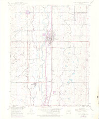
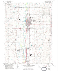
1949 Map of Fort Lupton
USGS Topo · Published 1970About this map
Fort Lupton serves as the central hub of this agricultural landscape, situated along the Union Pacific railroad lines in Weld County. The map captures a mid-century irrigation network essential to Colorado's Front Range farming, featuring an intricate system of waterways like the Fulton Ditch, Brantner Ditch, and Brighton Ditch drawing from the South Platte River. Small rural communities and stops such as Wattenberg and Powars dot the landscape, reflecting a time when local schools like Independence School and Wattenberg Sch were vital neighborhood landmarks. South of the main town, the Lupton Bottoms Ditch snakes through the river lowlands, while landmarks like Smith Mound and Hillside Cemetery provide distinct points of reference for genealogists and local historians tracing the development of this river valley.
Find a feature on this map
24 named features on this map. Tap any name to fly to it.
Don’t see what you’re looking for? This feature index may not catch every label — zoom into the map to look around manually.
Map Details
Editions of this 1949 Fort Lupton Map
6 editions found
Other maps of this area

1890 · East Denver
USGS Topo · 1:125,000

1902 · Greeley
USGS Topo · 1:125,000

1940 · Brighton
USGS Topo · 1:31,680

1940 · Eastlake
USGS Topo · 1:31,680

1942 · Mile High Lakes
USGS Topo · 1:31,680

1944 · Brighton
USGS Topo · 1:31,680

1944 · Eastlake
USGS Topo · 1:31,680

1949 · Gowanda
USGS Topo · 1:24,000

1949 · Fort Lupton
USGS Topo · 1:24,000

1949 · Platteville
USGS Topo · 1:24,000