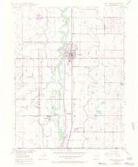
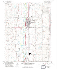
1949 Map of Fort Lupton
USGS Topo · Published 1970About this map
South Platte River waters dominate this Colorado landscape, fueling a complex irrigation network vital to the agricultural development of the mid-20th century. The town of Fort Lupton serves as the central hub, situated along the Union Pacific railroad corridor. Outside the main settlement, rural life is marked by local landmarks like Porter Sch, Wattenberg Sch, and Independence School, reflecting the community's dispersed but organized structure. A sophisticated system of canals, including the Fulton Ditch, Brighton Ditch, and Brantner Ditch, weaves through the river bottoms, illustrating how water rights shaped the early layout of Weld and Adams counties. To the west, a solitary Mine Dump hints at the industrial history of the area, while Smith Mound provides a distinct geographic anchor to the east.
Find a feature on this map
25 named features on this map. Tap any name to fly to it.
Don’t see what you’re looking for? This feature index may not catch every label — zoom into the map to look around manually.
Map Details
Editions of this 1949 Fort Lupton Map
6 editions found
Other maps of this area

1890 · East Denver
USGS Topo · 1:125,000

1902 · Greeley
USGS Topo · 1:125,000

1940 · Brighton
USGS Topo · 1:31,680

1940 · Eastlake
USGS Topo · 1:31,680

1942 · Mile High Lakes
USGS Topo · 1:31,680

1944 · Brighton
USGS Topo · 1:31,680

1944 · Eastlake
USGS Topo · 1:31,680

1949 · Gowanda
USGS Topo · 1:24,000

1949 · Fort Lupton
USGS Topo · 1:24,000

1949 · Platteville
USGS Topo · 1:24,000