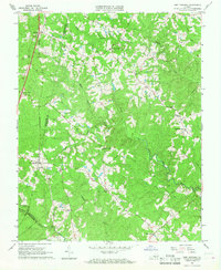
1966 Map of Fort Mitchell
USGS Topo · Published 1968About this map
The Middle Meherrin River and its various tributaries, including Knights Creek and Stokes Creek, carve through this rural landscape along the borders of Charlotte, Lunenburg, and Mecklenburg counties. During the mid-1960s, the region was defined by a network of local stores and community anchors such as Wallaces Store, Kunath Store, and Robertson Store. The Southern railroad line serves as a primary transit corridor, connecting the settlements of Ontario and Finneywood.
Find a feature on this map
31 named features on this map. Tap any name to fly to it.
Don’t see what you’re looking for? This feature index may not catch every label — zoom into the map to look around manually.
Map Details
Editions of this 1966 Fort Mitchell Map
2 editions found
Other maps of this area

1891 · Farmville
USGS Topo · 1:125,000

1892 · Appomattox
USGS Topo · 1:125,000

1893 · Farmville
USGS Topo · 1:125,000

1947 · Roanoke
USGS Topo · 1:250,000

1953 · Greensboro
USGS Topo · 1:250,000

1954 · Greensboro
USGS Topo · 1:250,000

1954 · Clover
USGS Topo · 1:62,500

1955 · Chase City
USGS Topo · 1:62,500

1956 · Charlotte Court House
USGS Topo · 1:62,500

1958 · Keysville
USGS Topo · 1:62,500