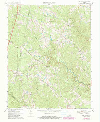
1966 Map of Fort Mitchell
USGS Topo · Published 1990About this map
Fort Mitchell serves as a central landmark in this rural Southside Virginia landscape, situated where the Middle Meherrin River and Meherrin River define the local topography. This 1966 survey, with 1990 photorevisions, documents a dispersed agricultural and residential pattern characterized by local commerce centers like Wallaces Store, Kunath Store, and Robertson Store. The importance of community institutions is evident through the presence of West End Sch and spiritual hubs such as Mt Mitchell Ch and Salem Ch.
Find a feature on this map
30 named features on this map. Tap any name to fly to it.
Don’t see what you’re looking for? This feature index may not catch every label — zoom into the map to look around manually.
Map Details
Editions of this 1966 Fort Mitchell Map
2 editions found
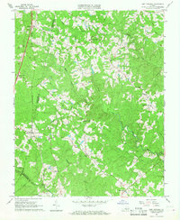
Other maps of this area

1891 · Farmville
USGS Topo · 1:125,000

1892 · Appomattox
USGS Topo · 1:125,000

1893 · Farmville
USGS Topo · 1:125,000

1947 · Roanoke
USGS Topo · 1:250,000

1953 · Greensboro
USGS Topo · 1:250,000

1954 · Greensboro
USGS Topo · 1:250,000

1954 · Clover
USGS Topo · 1:62,500

1955 · Chase City
USGS Topo · 1:62,500

1956 · Charlotte Court House
USGS Topo · 1:62,500

1958 · Keysville
USGS Topo · 1:62,500