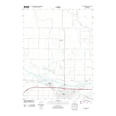
2010 Map of Fort Morgan
USGS Topo · Published 2010About this map
Fort Morgan serves as the focal point of this Eastern Plains landscape, where the South Platte River dictates the region's agricultural and civil development. The map reveals an intricate network of irrigation systems essential to the local economy, including the Fort Morgan Canal, Riverside Intake Canal, and the Deuel and Snyder Canal. These waterways support various local landmarks such as the Morgan Game and Fish Conservation Club Pond and Reid Ponds. To the north, the terrain is marked by ephemeral drainage features like Rock Spring Draw and Cris Lee Draw, while the city itself contains significant cultural sites including Riverside Cemetery and the Presbyterian Church Columbarium. The intersection of modern transportation and early engineering is visible at the Rainbow Bridge, which spans the river near the smaller settlements of Log Lane Village and Hurley.
Find a feature on this map
45 named features on this map. Tap any name to fly to it.
Don’t see what you’re looking for? This feature index may not catch every label — zoom into the map to look around manually.
Map Details
Editions of this 2010 Fort Morgan Map
This is the sole edition of this map. No revisions or reprints were ever made.
Other maps of this area

1951 · Weldona
USGS Topo · 1:24,000

1951 · Dead Horse Springs
USGS Topo · 1:24,000

1951 · Brush West
USGS Topo · 1:24,000

1951 · Peace Valley School
USGS Topo · 1:24,000

1951 · Judson Hills
USGS Topo · 1:24,000

1951 · Fort Morgan
USGS Topo · 1:24,000

1954 · Sterling
USGS Topo · 1:250,000

1958 · Sterling
USGS Topo · 1:250,000

1963 · Lamb
USGS Topo · 1:24,000

1963 · Round Top
USGS Topo · 1:24,000