1972 Map of Fort Peck
USGS Topo · Published 1975About this map
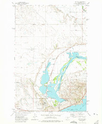
Hydraulic engineering and conservation efforts define the landscape of the Missouri River valley in the early 1970s. The massive Fort Peck Dam creates a sprawling transition between the river and Fort Peck Lake, influencing the local infrastructure through a complex of power plants, pumping stations, and an extensive aqueduct and pipeline system. The town of Fort Peck sits at the center of this managed environment, supported by local amenities like an Athletic Field and proximity to the Downstream Recreation Area.
Find a feature on this map
36 named features on this map. Tap any name to fly to it.
Don’t see what you’re looking for? This feature index may not catch every label — zoom into the map to look around manually.
Map Details
Editions of this 1972 Fort Peck Map
This is the sole edition of this map. No revisions or reprints were ever made.
Other maps of this area

1914 · Nashua
USGS Topo · 1:62,500

1916 · Nashua
USGS Topo · 1:62,500

1943 · Glasgow
USGS Topo · 1:125,000

1954 · Jordan
USGS Topo · 1:250,000

1954 · Glasgow
USGS Topo · 1:250,000

1956 · Jordan
USGS Topo · 1:250,000

1957 · Glasgow
USGS Topo · 1:250,000

1958 · Glasgow
USGS Topo · 1:250,000

1958 · Jordan
USGS Topo · 1:250,000
1958 · Wheeler
USGS Topo · 1:24,000