
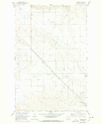
1958 Map of Wheeler
USGS Topo · Published 1960About this map
Wheeler serves as the primary landmark in this late 1950s survey of Valley County, where the landscape is defined by the complex drainage systems of the Missouri River Basin. The terrain transitions from the high ground of Tiger Butte in the north down through a series of deeply incised coulees, including Galpin Coulee, Wheeler Coulee, and Fullerton Coulee. These landforms reflect the arid character of the region, where water management and natural runoff dictated the layout of local infrastructure.
Find a feature on this map
15 named features on this map. Tap any name to fly to it.
Don’t see what you’re looking for? This feature index may not catch every label — zoom into the map to look around manually.
Map Details
Editions of this 1958 Wheeler Map
2 editions found
Other maps of this area

1914 · Nashua
USGS Topo · 1:62,500

1916 · Nashua
USGS Topo · 1:62,500

1943 · Glasgow
USGS Topo · 1:125,000

1954 · Jordan
USGS Topo · 1:250,000

1954 · Glasgow
USGS Topo · 1:250,000

1956 · Jordan
USGS Topo · 1:250,000

1957 · Glasgow
USGS Topo · 1:250,000

1958 · Glasgow
USGS Topo · 1:250,000

1958 · Jordan
USGS Topo · 1:250,000

1958 · Lewis Reservoir
USGS Topo · 1:24,000