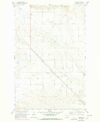
1958 Map of Wheeler
USGS Topo · Published 1978About this map
Tiger Butte overlooks a dissected landscape of winding coulees and intermittent drainages in this mid-century survey of Valley County. The settlement of Wheeler occupies the southeastern corner of the quadrangle, serving as a landmark near the sprawling Charles M Russell National Wildlife Range. The map documents a rural environment shaped by the Missouri River basin's development, featuring the Newton Sch and a network of pipelines traversing the high ground. Numerous water features, including Tiger Creek, Dogie Creek, and Dry Lake, illustrate the drainage patterns into Galpin Coulee and Fullerton Coulee. This 1958 field-checked record, later photorevised in the 1970s, captures the territory just as large-scale wildlife conservation efforts began to define the Missouri River's northern breaks.
Find a feature on this map
18 named features on this map. Tap any name to fly to it.
Don’t see what you’re looking for? This feature index may not catch every label — zoom into the map to look around manually.
Map Details
Editions of this 1958 Wheeler Map
2 editions found

Other maps of this area

1914 · Nashua
USGS Topo · 1:62,500

1916 · Nashua
USGS Topo · 1:62,500

1943 · Glasgow
USGS Topo · 1:125,000

1954 · Jordan
USGS Topo · 1:250,000

1954 · Glasgow
USGS Topo · 1:250,000

1956 · Jordan
USGS Topo · 1:250,000

1957 · Glasgow
USGS Topo · 1:250,000

1958 · Glasgow
USGS Topo · 1:250,000

1958 · Jordan
USGS Topo · 1:250,000

1958 · Lewis Reservoir
USGS Topo · 1:24,000