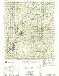
1977 Map of Fort Polk
USGS Topo · Published 1977About this map
The Fort Polk Military Reservation dominates this 1977 landscape, revealing the complex coexistence of military infrastructure and rural Louisiana life. While the southern sections show concentrated development around North Fort Polk and the Fort Polk Army Airfield, the surrounding terrain is heavily timbered within the Kisatchie National Forest. A network of numbered cemeteries, such as Cemetery No 6 and Cemetery No 10, are scattered throughout the training grounds, marking the locations of former communities and family homesteads absorbed by the installation.
Find a feature on this map
87 named features on this map. Tap any name to fly to it.
Don’t see what you’re looking for? This feature index may not catch every label — zoom into the map to look around manually.
Map Details
Editions of this 1977 Fort Polk Map
This is the sole edition of this map. No revisions or reprints were ever made.
Other maps of this area

1937 · Chopin SW
USGS Topo · 1:31,680

1941 · Leesville
USGS Topo · 1:62,500

1941 · Slagle
USGS Topo · 1:62,500

1942 · Florien
USGS Topo · 1:62,500

1942 · Kisatchie
USGS Topo · 1:62,500

1943 · Leesville
USGS Topo · 1:62,500

1943 · Leander
USGS Topo · 1:62,500

1943 · Kisatchie
USGS Topo · 1:62,500

1944 · Chopin
USGS Topo · 1:62,500

1944 · Florien
USGS Topo · 1:62,500