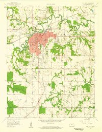
1958 Map of Fort Scott
USGS Topo · Published 1959About this map
Fort Scott serves as the focal point of this Bourbon County landscape in the late 1950s, characterized by a dense network of civic and educational institutions including Fort Scott Jr College and several specialized schools like Hawkins Sch and Ware Sch. The Marmaton River and Mill Creek wind through the terrain, providing natural drainage for an area heavily shaped by industrial activity. Extensive strip mines are visible throughout the eastern and northern portions of the quadrangle, indicating the region's historical reliance on coal extraction. Cultural and ancestral markers are prevalent, with numerous rural burying grounds such as St Marys Cem, Evergreen Cemetery, and Pine Lawn Cem situated near local landmarks like Bridal Veil Falls. The convergence of the Missouri Pacific and St Louis San Francisco railroads highlights the town's importance as a transportation hub during this era, while the Old Indian Boundary line provides a subtle reminder of the region's earlier territorial history.
Find a feature on this map
48 named features on this map. Tap any name to fly to it.
Don’t see what you’re looking for? This feature index may not catch every label — zoom into the map to look around manually.
Map Details
Editions of this 1958 Fort Scott Map
2 editions found
Other maps of this area

1884 · Fort Scott
USGS Topo · 1:125,000

1886 · Fort Scott
USGS Topo · 1:125,000

1893 · Fort Scott
USGS Topo · 1:125,000

1939 · Deerfield
USGS Topo · 1:24,000

1942 · Richards
USGS Topo · 1:24,000

1942 · Deerfield
USGS Topo · 1:24,000

1947 · Joplin
USGS Topo · 1:250,000

1948 · Mulberry
USGS Topo · 1:62,500

1948 · Girard
USGS Topo · 1:62,500
1948 · Garland
USGS Topo · 1:24,000