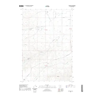
2020 Map of Fort Simcoe
USGS Topo · Published 2020About this map
Toppenish Ridge and the surrounding high country of Yakima County define this 2020 landscape, where modern resource management meets long-standing cultural landmarks. The map meticulously records sites of historical and genealogical importance, such as Colwash Cem and the areas designated simply as Graves near Simcoe Ln. This territory is characterized by a complex network of Bureau of Indian Affairs routes, including Bia RD 127 and Bia RD 100, which provide access to remote areas like Barbers Flat and the dramatic topography of Willy Dick Canyon. Water management is evident through the course of the Toppenish Lateral and the perennial flow of Agency Cr, while family-named landmarks such as Whiskey Jim Flat offer clues to the ranching and settlement history of the region. The map serves as a detailed guide for understanding the intersection of tribal land infrastructure and the natural drainage systems of Coon Canyon and Hunt Cr.
Find a feature on this map
41 named features on this map. Tap any name to fly to it.
Don’t see what you’re looking for? This feature index may not catch every label — zoom into the map to look around manually.
Map Details
Editions of this 2020 Fort Simcoe Map
This is the sole edition of this map. No revisions or reprints were ever made.
Other maps of this area

1937 · White Swan
USGS Topo · 1:125,000

1950 · Yakima
USGS Topo · 1:250,000

1957 · Yesmowit Canyon
USGS Topo · 1:24,000
1957 · Willy Dick Canyon
USGS Topo · 1:24,000

1958 · Toppenish Mtn.
USGS Topo · 1:24,000

1958 · Fort Simcoe
USGS Topo · 1:24,000

1958 · Fort Simcoe
USGS Topo · 1:62,500

1958 · White Swan
USGS Topo · 1:24,000
1958 · Medicine Valley
USGS Topo · 1:24,000

1958 · Yakima
USGS Topo · 1:250,000