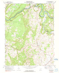
1971 Map of Fort Spring
USGS Topo · Published 1990About this map
The Greenbrier River carves a winding path through the northern reaches of this West Virginia landscape, dictated by the presence of Fort Spring Mountain. This 1971 survey captures an area defined by its early industrial and agricultural infrastructure, particularly where the Chesapeake and Ohio railroad utilizes engineered features like Manns Tunnel and Fort Spring Tunnel to navigate the river's sharp bends. Small settlements and points of interest such as Snowflake and Rockland are concentrated near these transit corridors, while the southern terrain transitions into the high ridges of Flat Top Mountain and the karst topography around Sinks Grove.
Find a feature on this map
50 named features on this map. Tap any name to fly to it.
Don’t see what you’re looking for? This feature index may not catch every label — zoom into the map to look around manually.
Map Details
Editions of this 1971 Fort Spring Map
2 editions found
Other maps of this area

1887 · Hinton
USGS Topo · 1:125,000

1887 · Lewisburg
USGS Topo · 1:125,000

1891 · Lewisburg
USGS Topo · 1:125,000

1892 · Hinton
USGS Topo · 1:125,000

1921 · Alderson
USGS Topo · 1:48,000

1921 · White Sulphur Springs
USGS Topo · 1:48,000

1921 · Clintonville
USGS Topo · 1:48,000

1921 · Ronceverte
USGS Topo · 1:48,000

1923 · Clintonville
USGS Topo · 1:62,500

1923 · White Sulphur Springs
USGS Topo · 1:62,500