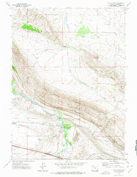
1971 Map of Fort Steele
USGS Topo · Published 1975About this map
The North Platte River carves a critical path through the high desert of Carbon County, anchoring a landscape where military history and heavy industry meet. At the river's bend, the Fort Fred Steele (Site) marks the location of a late 19th-century frontier post established to protect the transcontinental railroad. By the early 1970s, the adjacent settlement of Fort Steele and the nearby Sinclair East Base reflect the area's continued role as a transportation and logistics corridor. The Union Pacific railroad runs parallel to the water, flanked by the Fort Steele Breaks and Saint Marys Ridge. This topography is shaped by dramatic elevation changes, from the heights of Mount Steele down to Alkali Flat. Local resource extraction is evident in the numerous Gravel Pits and a Mine located along the ridges, while a small Cem remains a quiet marker of the region's earlier residents.
Find a feature on this map
27 named features on this map. Tap any name to fly to it.
Don’t see what you’re looking for? This feature index may not catch every label — zoom into the map to look around manually.
Map Details
Editions of this 1971 Fort Steele Map
This is the sole edition of this map. No revisions or reprints were ever made.
Other maps of this area

1893 · Fort Steele
USGS Topo · 1:125,000

1914 · Walcott
USGS Topo · 1:62,500

1953 · Sinclair
USGS Topo · 1:24,000

1953 · Lone Haystack Mountain
USGS Topo · 1:24,000

1954 · Rawlins
USGS Topo · 1:250,000

1955 · Meads
USGS Topo · 1:24,000

1955 · Savage Ranch
USGS Topo · 1:24,000

1956 · Bolten Ranch
USGS Topo · 1:62,500

1958 · Rawlins
USGS Topo · 1:250,000

1962 · Rawlins
USGS Topo · 1:250,000