
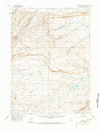
1956 Map of Bolten Ranch
USGS Topo · Published 1959About this map
Overland Trail history is clearly visible on this 1950s survey of the Wyoming high country, where the historic thoroughfare cuts across the landscape near Bolten Ranch. This cattle ranching and coal-mining district is defined by a series of deep drainage draws and creeks, including Little Sage Creek and La Marsh Creek. The topography is dominated by prominent landmarks like Sheep Mtn and the distinctively named Choke Cherry Knob, providing a clear picture of the terrain before modern development altered these routes.
Find a feature on this map
23 named features on this map. Tap any name to fly to it.
Don’t see what you’re looking for? This feature index may not catch every label — zoom into the map to look around manually.
Map Details
Editions of this 1956 Bolten Ranch Map
2 editions found
Other maps of this area

1893 · Fort Steele
USGS Topo · 1:125,000

1914 · Walcott
USGS Topo · 1:62,500

1932 · Savery
USGS Topo · 1:96,000

1939 · Saratoga
USGS Topo · 1:125,000

1940 · Savery
USGS Topo · 1:125,000

1953 · Sinclair
USGS Topo · 1:24,000

1953 · Rawlins
USGS Topo · 1:24,000

1954 · Rawlins
USGS Topo · 1:250,000

1955 · Overland Crossing
USGS Topo · 1:24,000

1955 · Savage Ranch
USGS Topo · 1:24,000