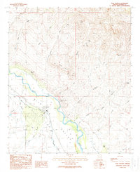
1989 Map of Fort Thomas
USGS Topo · Published 1990About this map
Fort Thomas sits as a primary settlement within the fertile Gila Valley, where the irrigation of the Gila River has long supported local life. This late twentieth-century record highlights the complex hydraulic infrastructure essential to this arid region, including the Fort Thomas Canal and Curtis Canal. To the north, the terrain rises sharply into the Black Hills and Red Hills, cut by numerous drainage systems such as Day Mine Wash and Porter Wash.
Find a feature on this map
28 named features on this map. Tap any name to fly to it.
Don’t see what you’re looking for? This feature index may not catch every label — zoom into the map to look around manually.
Map Details
Editions of this 1989 Fort Thomas Map
This is the sole edition of this map. No revisions or reprints were ever made.
Other maps of this area
1944 · Jackson Mtn.
USGS Topo · 1:62,500

1946 · Jackson Mtn.
USGS Topo · 1:62,500

1954 · Silver City
USGS Topo · 1:250,000

1954 · Clifton
USGS Topo · 1:250,000

1954 · Mesa
USGS Topo · 1:250,000

1956 · Tucson
USGS Topo · 1:250,000

1957 · Mesa
USGS Topo · 1:250,000

1957 · Clifton
USGS Topo · 1:250,000

1958 · Silver City
USGS Topo · 1:250,000

1958 · Clifton
USGS Topo · 1:250,000