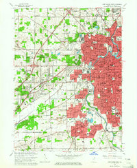
1963 Map of Fort Wayne West
USGS Topo · Published 1965About this map
Fort Wayne expands westward across this 1963 survey, where the confluence of the St Marys River and the Maumee River defines the city's early geography. The urban core is a dense network of civic and religious institutions, including the City Hall, Courthouse, and the expansive Lindenwood Cemetery. Education and social welfare are prominent themes, evidenced by the Indiana School for Feeble Minded Youth, St Vincents Orphan Home, and several collegiate campuses like St Francis College. Beyond the city limits, a postwar suburban pattern emerges in residential developments such as Waynedale, Brierwood Hills, and Lincolnshire. Transportation is dominated by a heavy rail presence, with the Pennsylvania Railroad, Wabash Railroad, and the New York Chicago and St Louis Railroad converging near the industrial and commercial centers.
Find a feature on this map
182 named features on this map. Tap any name to fly to it.
Don’t see what you’re looking for? This feature index may not catch every label — zoom into the map to look around manually.
Map Details
Editions of this 1963 Fort Wayne West Map
4 editions found
Other maps of this area

1953 · Fort Wayne
USGS Topo · 1:250,000

1953 · Muncie
USGS Topo · 1:250,000

1956 · Muncie
USGS Topo · 1:250,000

1956 · Fort Wayne
USGS Topo · 1:250,000

1956 · Fort Wayne West
USGS Topo · 1:24,000

1956 · Fort Wayne East
USGS Topo · 1:24,000

1956 · Cedarville
USGS Topo · 1:24,000

1957 · Huntertown
USGS Topo · 1:24,000

1957 · Churubusco
USGS Topo · 1:24,000

1961 · Arcola
USGS Topo · 1:24,000
Featured Places
- Fort Wayne, IN
- Indian Village, Fort Wayne
- Northcrest, Fort Wayne
- Ansley Acres, IN
- Westchester, Fort Wayne