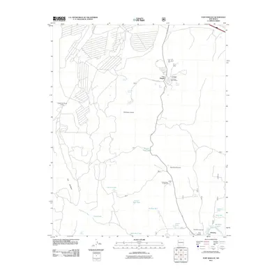
2011 Map of Fort Wingate
USGS Topo · Published 2011About this map
Fort Wingate serves as a focal point for this high-desert landscape, anchored by its post office and the Fort Wingate Historic District. The settlement pattern is defined by essential water sources and seasonal drainages, where numerous tanks and springs like Bear Spring and Wingate Stock Tank support the local environment. To the south, the village of McGaffey sits near the McGaffey Lake Dam, marking a transition from the structured military-industrial history of the fort to the recreational and forested terrain of the Quaking Aspen Campground. Distinctive geological features such as The Hogback and Milk Ranch Canyon shape the movement across the territory, connected by historical routes like Rte 66 and local trails including Shush and the Painted Horse Trl. This documentation of the Eastern Navajo Agency land reflects a complex network of ranching infrastructure and early 20th-century preservation.
Find a feature on this map
36 named features on this map. Tap any name to fly to it.
Don’t see what you’re looking for? This feature index may not catch every label — zoom into the map to look around manually.
Map Details
Editions of this 2011 Fort Wingate Map
This is the sole edition of this map. No revisions or reprints were ever made.
Other maps of this area

1886 · Wingate
USGS Topo · 1:250,000

1892 · Wingate
USGS Topo · 1:250,000

1954 · Gallup
USGS Topo · 1:250,000

1958 · Gallup
USGS Topo · 1:250,000

1959 · Gallup
USGS Topo · 1:250,000

1962 · Gallup
USGS Topo · 1:250,000

1962 · Ciniza
USGS Topo · 1:24,000

1962 · Page
USGS Topo · 1:24,000
1963 · Pinedale
USGS Topo · 1:24,000
1963 · Church Rock
USGS Topo · 1:24,000