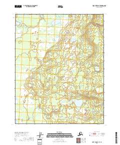
2018 Map of Fort Yukon B-1 SE
USGS Topo · Published 2018About this map
The low-lying interior of the Yukon-Koyukuk region is defined by a dense concentration of wetlands and small lakes in this 2018 survey. The landscape is structured by the Public Land Survey System grids of T18n R16e, T18n R17e, T17n R16e, and T17n R17e, which delineate the territory north of the Arctic Circle. The lack of named roads or permanent settlements emphasizes the remote nature of this terrain, where hydrography is the dominant physical characteristic. Researchers interested in the topography of the Yukon Flats will find a detailed representation of the basin's complex water network and subtle elevation changes within the Porcupine River drainage area.
Find a feature on this map
4 named features on this map. Tap any name to fly to it.
Don’t see what you’re looking for? This feature index may not catch every label — zoom into the map to look around manually.
Map Details
Editions of this 2018 Fort Yukon B-1 SE Map
This is the sole edition of this map. No revisions or reprints were ever made.
Other maps of this area

1951 · Fort Yukon
USGS Topo · 1:250,000

1951 · Black River
USGS Topo · 1:250,000

1956 · Black River B-6
USGS Topo · 1:63,360

1956 · Fort Yukon B-1
USGS Topo · 1:63,360

1956 · Fort Yukon A-1
USGS Topo · 1:63,360

1956 · Black River A-6
USGS Topo · 1:63,360

1956 · Fort Yukon
USGS Topo · 1:250,000

1956 · Black River
USGS Topo · 1:250,000

1964 · Black River
USGS Topo · 1:250,000
2018 · Fort Yukon B-1 NW
USGS Topo · 1:25,000