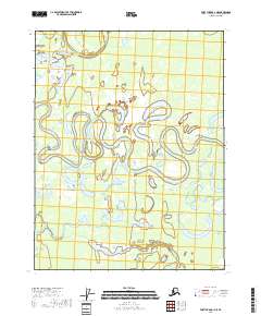
2018 Map of Fort Yukon C-1 NE
USGS Topo · Published 2018About this map
The Draanjik River meanders heavily through this Interior Alaska landscape, creating a complex network of oxbows, sloughs, and shallow lakes. The terrain is defined by the shifting nature of these waterways, exemplified by features like Graveyard Slough and the nearby Graveyard Lakes in the north. This 2018 survey reveals a topography where water dominates the land, with subtle features like the John Ross Riffle indicating specific points of riverbed change along the Draanjik's course. Farther south, the environment transitions into larger standing water bodies such as Tsiyeehvun Lake and Applevun Lake. The lack of road infrastructure and the prevalence of landmarks like John Kwilliit Slough highlight a region where transport and seasonal movement are historically dictated by the flow of the river system within the Yukon-Koyukuk Census Area.
Find a feature on this map
11 named features on this map. Tap any name to fly to it.
Don’t see what you’re looking for? This feature index may not catch every label — zoom into the map to look around manually.
Map Details
Editions of this 2018 Fort Yukon C-1 NE Map
This is the sole edition of this map. No revisions or reprints were ever made.
Other maps of this area

1951 · Fort Yukon
USGS Topo · 1:250,000

1951 · Black River
USGS Topo · 1:250,000

1956 · Fort Yukon C-1
USGS Topo · 1:63,360

1956 · Black River D-6
USGS Topo · 1:63,360

1956 · Black River C-6
USGS Topo · 1:63,360
1956 · Fort Yukon D-1
USGS Topo · 1:63,360

1956 · Fort Yukon
USGS Topo · 1:250,000

1956 · Black River
USGS Topo · 1:250,000

1964 · Black River
USGS Topo · 1:250,000
2018 · Fort Yukon D-1 SW
USGS Topo · 1:25,000