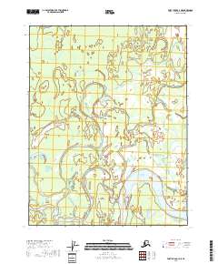
2018 Map of Fort Yukon C-3 NE
USGS Topo · Published 2018About this map
The Porcupine River carves a massive, winding path through the southeastern corner of this landscape, a vital waterway within the broader Yukon Flats region. This low-lying wilderness is characterized by a complex network of shifting water channels, most notably the Nuntragut Slough, which meanders across the central and northern reaches of the terrain. The geography here is defined by fluvial processes, where seasonal changes and water levels dictate the shape of landmasses like Rodman Island. The absence of roads or permanent structures reflects the extreme isolation of this river-and-wetland environment, which remains a critical habitat for migratory birds and local wildlife. For researchers, the map provides a precise look at the drainage patterns and township boundaries of T21N and T22N in the heart of one of Alaska’s most significant interior basins.
Find a feature on this map
8 named features on this map. Tap any name to fly to it.
Don’t see what you’re looking for? This feature index may not catch every label — zoom into the map to look around manually.
Map Details
Editions of this 2018 Fort Yukon C-3 NE Map
This is the sole edition of this map. No revisions or reprints were ever made.
Other maps of this area

1951 · Fort Yukon
USGS Topo · 1:250,000

1952 · Fort Yukon C-2
USGS Topo · 1:63,360

1952 · Fort Yukon C-3
USGS Topo · 1:63,360

1955 · Fort Yukon D-2
USGS Topo · 1:63,360

1955 · Fort Yukon D-3
USGS Topo · 1:63,360

1955 · Fort Yukon C-3
USGS Topo · 1:63,360

1956 · Fort Yukon
USGS Topo · 1:250,000
1956 · Fort Yukon D-3
USGS Topo · 1:63,360
1956 · Fort Yukon C-2
USGS Topo · 1:63,360
2018 · Fort Yukon D-3 SE
USGS Topo · 1:25,000