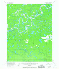
1956 Map of Fort Yukon C-2
USGS Topo · Published 1967About this map
The Sheenjek River and Porcupine River dominate this 1950s landscape, where a complex network of sloughs and lakes defines the low-lying terrain of interior Alaska. The map documents a sparsely settled wilderness characterized by seasonal watercourses and remote shelters, such as the Joe Carroll Cabin and other unnamed cabins that likely served as essential outposts for trappers or travelers. The hydrological detail is particularly high, tracing the winding paths of the Black River and the Sucker River as they meander through a labyrinth of oxbows and marshy ground.
Find a feature on this map
24 named features on this map. Tap any name to fly to it.
Don’t see what you’re looking for? This feature index may not catch every label — zoom into the map to look around manually.
Map Details
Editions of this 1956 Fort Yukon C-2 Map
This is the sole edition of this map. No revisions or reprints were ever made.
Other maps of this area

1951 · Fort Yukon
USGS Topo · 1:250,000

1952 · Fort Yukon C-2
USGS Topo · 1:63,360

1952 · Fort Yukon C-3
USGS Topo · 1:63,360

1955 · Fort Yukon D-2
USGS Topo · 1:63,360

1955 · Fort Yukon D-3
USGS Topo · 1:63,360

1955 · Fort Yukon C-3
USGS Topo · 1:63,360

1956 · Fort Yukon C-1
USGS Topo · 1:63,360

1956 · Fort Yukon B-3
USGS Topo · 1:63,360

1956 · Fort Yukon B-1
USGS Topo · 1:63,360

1956 · Fort Yukon B-2
USGS Topo · 1:63,360