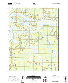
2018 Map of Fort Yukon C-4 SW
USGS Topo · Published 2018About this map
Venetie Landing serves as a lone point of reference in this intricate water landscape within the Yukon-Koyukuk region. The sheet is dominated by the massive, braided path of the Yukon River, which fragments into a complex network of secondary channels and backwaters. The map illustrates how the river's flow is redirected through features like Buck Yukon Slough and Nuntragut Slough, creating a terrain of seasonal wetlands and shifting gravel bars. This environment reflects the dynamic nature of the subarctic interior, where the river's movement dictates the possibility of seasonal access and habitation. The absence of roads emphasizes the complete reliance on the waterway for transportation and subsistence in this corner of Alaska.
Find a feature on this map
10 named features on this map. Tap any name to fly to it.
Don’t see what you’re looking for? This feature index may not catch every label — zoom into the map to look around manually.
Map Details
Editions of this 2018 Fort Yukon C-4 SW Map
This is the sole edition of this map. No revisions or reprints were ever made.
Other maps of this area

1951 · Fort Yukon
USGS Topo · 1:250,000

1952 · Fort Yukon C-4
USGS Topo · 1:63,360

1955 · Fort Yukon C-5
USGS Topo · 1:63,360

1956 · Fort Yukon B-4
USGS Topo · 1:63,360

1956 · Fort Yukon C-5
USGS Topo · 1:63,360

1956 · Fort Yukon B-5
USGS Topo · 1:63,360

1956 · Fort Yukon
USGS Topo · 1:250,000
1956 · Fort Yukon C-4
USGS Topo · 1:63,360
2018 · Fort Yukon C-4 NW
USGS Topo · 1:25,000
2018 · Fort Yukon C-5 NE
USGS Topo · 1:25,000