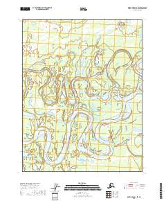
2018 Map of Fort Yukon D-1 SE
USGS Topo · Published 2018About this map
The Porcupine River dominates this portion of the Yukon Flats, winding through a complex system of active and abandoned channels. This 2018 survey documents the intricate hydrology of the region, where the river's path is marked by dramatic features like Bootleg Bend. The landscape is defined by the constant shifting of water across the floodplain, creating numerous side channels including Curtis Slough, Goose Slough, and Ninemile Slough. These features illustrate the dynamic nature of the Alaskan interior, where the lack of human infrastructure emphasizes the raw power of the river system. Researchers interested in fluvial geomorphology or the remote geography of the Yukon-Koyukuk region will find the precise mapping of these water bodies essential for understanding the seasonal changes and historical movement of the water across the flats.
Find a feature on this map
12 named features on this map. Tap any name to fly to it.
Don’t see what you’re looking for? This feature index may not catch every label — zoom into the map to look around manually.
Map Details
Editions of this 2018 Fort Yukon D-1 SE Map
This is the sole edition of this map. No revisions or reprints were ever made.
Other maps of this area

1951 · Fort Yukon
USGS Topo · 1:250,000

1951 · Black River
USGS Topo · 1:250,000

1956 · Fort Yukon C-1
USGS Topo · 1:63,360

1956 · Black River D-6
USGS Topo · 1:63,360

1956 · Black River C-6
USGS Topo · 1:63,360
1956 · Fort Yukon D-1
USGS Topo · 1:63,360

1956 · Fort Yukon
USGS Topo · 1:250,000

1956 · Black River
USGS Topo · 1:250,000

1964 · Black River
USGS Topo · 1:250,000
2018 · Black River D-6 NW
USGS Topo · 1:25,000