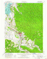
1959 Map of Fortuna
USGS Topo · Published 1961About this map
The Eel River and Van Duzen River define the lower Eel River Valley in this mid-century survey, a landscape where timber and dairy interests meet the Pacific coast. The town of Fortuna serves as the regional hub, supported by the Northwestern Pacific Railroad which connects the coastal timber ports at Fields Landing to the inland logging operations. The map details a established social infrastructure, featuring the Union High School and Redwood Memorial Hospital in the town center, while the Rohnerville Airport and St Pius X Seminary suggest post-war expansion. Local history is etched into the terrain at Grizzly Bluff and Table Bluff, overlooking the marshes of the South Bay. This geography highlights the intricate water systems necessary for the era's industry, from the Hookton Slough to the many gulches and forks of the Elk River.
Find a feature on this map
64 named features on this map. Tap any name to fly to it.
Don’t see what you’re looking for? This feature index may not catch every label — zoom into the map to look around manually.
Map Details
Editions of this 1959 Fortuna Map
2 editions found
Other maps of this area

1916 · Cape Fortunas
USGS Topo · 1:62,500

1919 · Glynn
USGS Topo · 1:62,500

1921 · Dyerville
USGS Topo · 1:62,500

1921 · Cape Mendocino
USGS Topo · 1:62,500

1922 · Eureka
USGS Topo · 1:62,500

1922 · Korbel
USGS Topo · 1:62,500

1922 · Kneeland
USGS Topo · 1:62,500

1933 · Eureka
USGS Topo · 1:48,000

1942 · Eureka
USGS Topo · 1:62,500

1943 · Ferndale
USGS Topo · 1:62,500