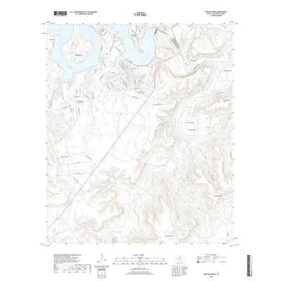
2019 Map of Fortune Bend
USGS Topo · Published 2019About this map
Possum Kingdom Lake dominates the northern landscape of this region, where the Brazos River carves deep, dramatic loops through Palo Pinto County. These sharp river bends define the local geography, from Hog Bend in the northwest to the eponymous Fortune Bend in the east. The terrain is marked by significant elevations like Schoolhouse Mtn and Crawford Mtn, which overlook a network of seasonal drainages including Ioni Creek and Harris Br. Residential development and leisure infrastructure are concentrated along the northern shorelines, evidenced by the clustered street networks of Gaines Bend and Frank Harris Bend, as well as the Sportsman's World Airport. This 2019 survey illustrates the intersection of rugged Texas hill country with modern recreational growth, showing how road networks like Park Rd 36 and Brackeen Ranch Rd navigate the challenging topography of Doan Hollow and Crawford Hollow.
Find a feature on this map
72 named features on this map. Tap any name to fly to it.
Don’t see what you’re looking for? This feature index may not catch every label — zoom into the map to look around manually.
Map Details
Editions of this 2019 Fortune Bend Map
This is the sole edition of this map. No revisions or reprints were ever made.
Other maps of this area

1890 · Breckenridge
USGS Topo · 1:125,000

1891 · Palo Pinto
USGS Topo · 1:125,000

1918 · Palo Pinto
USGS Topo · 1:125,000

1924 · Breckenridge 1-a
USGS Topo · 1:48,000

1924 · Palo Pinto 2-b
USGS Topo · 1:48,000

1924 · Palo Pinto 2-a
USGS Topo · 1:48,000

1924 · Palo Pinto 2-c
USGS Topo · 1:48,000

1924 · Breckenridge 1-d
USGS Topo · 1:48,000

1927 · Pickwick
USGS Topo · 1:62,500

1931 · Ivan
USGS Topo · 1:62,500