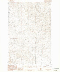
1983 Map of Fortyfour Coulee
USGS Topo · Published 1983About this map
Fortyfour Coulee and its neighboring drainages define this portion of McCone County, Montana, during the early 1980s. The landscape is a network of deeply etched coulees and intermittent watercourses, reflecting a typical High Plains erosion pattern. Names like Timber Coulee, Shed Coulee, and Meadows Coulee suggest a history of localized land use, perhaps tied to early ranching and livestock shelter. Higher elevations such as Cobb Hill provide vantage points over the surrounding breaks. Water management is sparse but evident through the presence of the Leaky Reservoir in the northern reaches, while larger drainage systems like Ten Deer Creek and its tributary East Ten Deer Creek dominate the southern half of the quadrangle. This map serves as a record of the intricate topographical detail of the Big Dry country before more modern infrastructure changes.
Find a feature on this map
18 named features on this map. Tap any name to fly to it.
Don’t see what you’re looking for? This feature index may not catch every label — zoom into the map to look around manually.
Map Details
Editions of this 1983 Fortyfour Coulee Map
This is the sole edition of this map. No revisions or reprints were ever made.
Other maps of this area

1954 · Jordan
USGS Topo · 1:250,000

1956 · Jordan
USGS Topo · 1:250,000

1958 · Jordan
USGS Topo · 1:250,000

1964 · Jordan
USGS Topo · 1:250,000

1967 · Coal Creek
USGS Topo · 1:24,000

1967 · Frank Coulee
USGS Topo · 1:24,000

1972 · Short Creek
USGS Topo · 1:24,000

1973 · Rodgers Hall
USGS Topo · 1:24,000

1973 · Nelson Creek Bay
USGS Topo · 1:24,000

1978 · Fort Peck Lake East
USGS Topo · 1:100,000