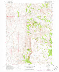
1966 Map of Fortynine Mtn.
USGS Topo · Published 1982About this map
Fortynine Mountain dominates this remote high-desert landscape, straddling the state line between Nevada and California. The 1960s terrain is defined by its vital water sources, from Farmer Spring and Koenig Spring in the south to Quaking Asp Spring tucked within Eagle Gulch. This arid expanse transitions from the flat floor of Surprise Valley in the west to the steep slopes of the mountain range, where ephemeral drainages like Fortynine Creek and Secret Creek carve through the basin and range geology. The presence of Fortynine Camp and the Dugway Road suggest a landscape utilized for seasonal ranching or resource management, while the Long Valley (Depression) marks a distinct topographical low point in the northeast corner. This survey highlights the critical intersection of Washoe County, Nevada, and Modoc County, California, at a time when these water points were the primary landmarks for navigation across the high desert.
Find a feature on this map
23 named features on this map. Tap any name to fly to it.
Don’t see what you’re looking for? This feature index may not catch every label — zoom into the map to look around manually.
Map Details
Editions of this 1966 Fortynine Mtn. Map
3 editions found
Other maps of this area

1886 · Alturas
USGS Topo · 1:250,000

1889 · Long Valley
USGS Topo · 1:250,000

1892 · Alturas
USGS Topo · 1:250,000

1954 · Vya
USGS Topo · 1:250,000

1954 · Alturas
USGS Topo · 1:250,000

1958 · Alturas
USGS Topo · 1:250,000

1958 · Vya
USGS Topo · 1:250,000

1962 · Alturas
USGS Topo · 1:250,000

1962 · Vya
USGS Topo · 1:250,000

1962 · Cedarville
USGS Topo · 1:62,500