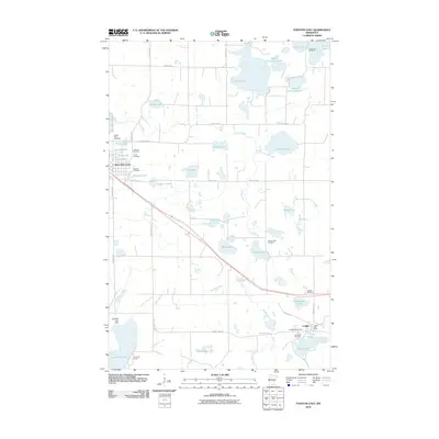
2010 Map of Fosston East
USGS Topo · Published 2010About this map
Saint Paul's Cemetery and Immanuel Cemetery sit near the eastern edge of this landscape, marking the established community life near the Lengby Post Office. The area is defined by a dense concentration of glacial lakes and wetlands, where small water bodies like Volden Lake, Haslie Lake, and Whitefish Lake are connected by the winding Poplar River. This 2010 survey shows the intersection of rural township roads and the modern highway corridor, featuring the Lengby Rest Area and several family-named landmarks. Numerous small cemeteries, including Landstad Cemetery, Kingo Cemetery, and Rosehill Cemetery, are scattered across the terrain, providing significant points of interest for genealogists tracking early settlers in this pocket of Polk County. To the south, the Sand Hill Lake Dam and Sand Hill Camp reflect the local utility of the Sand Hill Lake and Sand Hill River system.
Find a feature on this map
48 named features on this map. Tap any name to fly to it.
Don’t see what you’re looking for? This feature index may not catch every label — zoom into the map to look around manually.
Map Details
Editions of this 2010 Fosston East Map
This is the sole edition of this map. No revisions or reprints were ever made.
Other maps of this area

1919 · Fosston
USGS Topo · 1:62,500

1954 · Bemidji
USGS Topo · 1:250,000

1957 · Bemidji
USGS Topo · 1:250,000

1958 · Bemidji
USGS Topo · 1:250,000

1969 · Ebro
USGS Topo · 1:24,000

1969 · Olga
USGS Topo · 1:24,000

1969 · Mc Intosh NE
USGS Topo · 1:24,000

1969 · Fosston SE
USGS Topo · 1:24,000

1969 · Fosston East
USGS Topo · 1:24,000

1969 · Fosston West
USGS Topo · 1:24,000