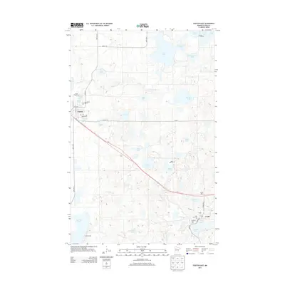
2013 Map of Fosston East
USGS Topo · Published 2013About this map
Fosston and Lengby anchor this Polk County landscape, which is defined by a dense concentration of glacial lakes and the winding course of the Poplar River. The area's settlement history is etched into the terrain through a remarkable density of community burial grounds, including Rosehill Cem, Kingo Cem, and Landstad Cem near the town center. To the southeast, the village of Lengby sits near the headwaters of the Sand Hill River, served by Us-2 and featuring localized landmarks like the Saint Paul's and Immanuel Cem sites. This 2013 survey illustrates the modern road network connecting these rural hubs, while the complex hydrology—from Turtle Lake in the north to Sand Hill Lake in the southwest—continues to shape the region's character. Local historians will find the exact placement of these small-town institutions and water bodies invaluable for tracing late 20th and early 21st-century development.
Find a feature on this map
53 named features on this map. Tap any name to fly to it.
Don’t see what you’re looking for? This feature index may not catch every label — zoom into the map to look around manually.
Map Details
Editions of this 2013 Fosston East Map
This is the sole edition of this map. No revisions or reprints were ever made.
Other maps of this area

1919 · Fosston
USGS Topo · 1:62,500

1954 · Bemidji
USGS Topo · 1:250,000

1957 · Bemidji
USGS Topo · 1:250,000

1958 · Bemidji
USGS Topo · 1:250,000

1969 · Ebro
USGS Topo · 1:24,000

1969 · Olga
USGS Topo · 1:24,000

1969 · Mc Intosh NE
USGS Topo · 1:24,000

1969 · Fosston SE
USGS Topo · 1:24,000

1969 · Fosston East
USGS Topo · 1:24,000

1969 · Fosston West
USGS Topo · 1:24,000