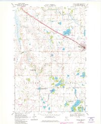
1969 Map of Fosston West
USGS Topo · Published 1982About this map
Fosston sits at the edge of this Polk County landscape, serving as a focal point for the region’s transport and recreation in the late 1960s. The Burlington Northern railroad cuts a diagonal path across the terrain, passing just north of the Fairground and the Fosston Municipal Airport, which notably includes a Seaplane Facility on the waters of Ouff Lake.
Find a feature on this map
36 named features on this map. Tap any name to fly to it.
Don’t see what you’re looking for? This feature index may not catch every label — zoom into the map to look around manually.
Map Details
Editions of this 1969 Fosston West Map
2 editions found
Other maps of this area

1919 · Fosston
USGS Topo · 1:62,500

1954 · Bemidji
USGS Topo · 1:250,000

1957 · Bemidji
USGS Topo · 1:250,000

1958 · Bemidji
USGS Topo · 1:250,000

1969 · Olga
USGS Topo · 1:24,000

1969 · Mc Intosh NE
USGS Topo · 1:24,000

1969 · Fosston East
USGS Topo · 1:24,000
1969 · Mc Intosh
USGS Topo · 1:24,000

1969 · Fosston West
USGS Topo · 1:24,000
1969 · Winger
USGS Topo · 1:24,000